
Chaco Culture National Historic Park
Saturday is proving to be a good day for a road trip! This past Saturday, we headed south about 80 miles to what is commonly called "Chaco Canyon". This National Historic Park was established in 1907 to preserve a part of ancestral Puebloan culture. The site proved to be very interesting and informative. The road to the park, however, was disgusting... 15 + miles of washboard and washouts. Once again, I was glad we had the Jeep and wondered about the sanity of those who were taking trailers and motorhomes to the park's campground... it was full, by the way. Anyway, let me tell you about our day.
Fajada Butte is visible from all of the "ruins" within Chaco Canyon. You will hear more about this landmark at the end of the entry.

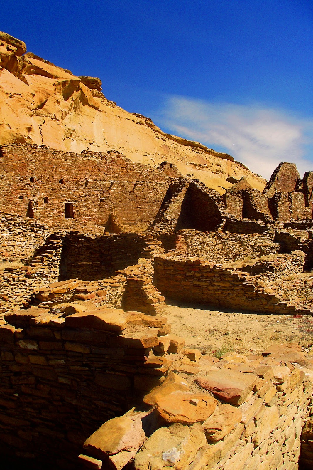
At first glance, it is easy to miss the ruins and only see the magnificent walls of the canyon.

When you look more closely, you see that the chacoans were master builders - look at the width of the walls

Can you see the moon barely visible?

The archeologists who have studied the area recognize that by the 1700's the Navajo settlement was well established in Chaco Canyon. Whenever you see limbs, it is important to note that all logs came from 50 - 60 miles away and were transported the only way available - walking. Although some may have been floated down the river that must have been flowed throught he canyon at the time.

Pueblo Bonita was the first area excavated. Richard Wetherhill, who had worked at Mesa Verde, lived and worked in the area in the early 1900's. The area was mapped at that time.

Like all of the great houses in the Canyon area, Bonita has been "back filled" to prevent the foundation from caving in and to preserve the historical artifacts. Back filling is filling in the bottom with several feet of gravel.

Mike is admiring the workmanship. Notice the doorway that is T-shaped - all outside doors had this shape. I wondered about the square corners and thought perhaps it had been "reconstructed" but found that this precision was part of the original buildings.

These structures were two stories tall with the width of the walls being thicker at the bottom than at the top. The wood you see sticking out of the wall would have been the floor of the second story.

This is one of the Kivas in Pueblo Bonita. Kivas are found in all communities from the 800's to the 1200's. They were usually found in the plazas of the community and their use was for ceremonial purposes. Kivas are still a part of many of today's Native American Communities - the purpose remains the same.


Being in a place like this with such amazing history calls for a couple pic.

The pile of rubble on which we are standing was a giant 97 foot rock stretching into the sky directly behind this Pueblo. It was 140 feet long and 34 feet thick. It fell in the 1940's during a storm - can you imagine the sound... the collapse destroyed about thirty rooms that had been excavated in the 1920's

This fellow still looks over it all.

Mike spotted this rock and wonders how much longer it will stand.

There are a few petroglyphs; but much of the area has been desecrated.

Everywhere we see petroglyphs, there is a circular mark... a beginning and an ending - cycle of life perhaps... do the number of rings mean something???

This is a well preserved Kiva - notice the circular shape in the upper right - there were four of these that held pillars which supported the roof - one was in each of the four directions. A fireplace is in the center.

At this Pueblo, built a little later than Bonita,

we saw great views of the surrounding canyon,


and an example of how a floor would have been constructed.

At the Kiva at his location was totally amazing!

It was round and built much like all the others but

it was the largest Kiva in Chaco Canyon and one of the largest in the entire Chacoan world and the north and south entrances are set on a north-south axis - WITHIN ONE DEGREE OF TRUE NORTH.

And there was a below ground entrance. This was and is a sacred area in the Hopi and Navajo cultures.

While I am talking about precision and alignment in the the universe. Chacoans were very aware of the solar and lunar changes and its significance. The ancients had solar and lunar sky watchers who announced the seasons by monitoring the cycles of the sun and the moon - solstices were marked by ceremonies - ceremonies held at the very site where we were standing - over 1000 years ago - WOW.
So, now, back to Fajada Butte - the Solstice Marker. On the top of this butte are three large upright rock slabs - they stand in front of two spiral petroglyphs carved by the ancients. As sunlight passes through these slabs on the spring anf fall equinoxes and the winter and summer solstices, dagger-shaped beams of light appear at various points on the spirals. This functioned as a calendrical marker for the people of the Chaco Canyon.

Before this area was declared off limits, much destruction took place, but you see the idea in the picture below.

This is one amazing place... oh, did I tell you that there are over 400 miles of ancient roadways that run throughout the canyon... all perfectly north/south or east/west.

And in that design, if a mountain was encountered, they went over it with a series of steps. Oh, and all the roadways were exactly 30 feet wide...

These ancestors of the Navajo and Hopi were master builders, astronomers, and agriculturalists - a history of which to be proud.
Fajada Butte is visible from all of the "ruins" within Chaco Canyon. You will hear more about this landmark at the end of the entry.

At first glance, it is easy to miss the ruins and only see the magnificent walls of the canyon.

When you look more closely, you see that the chacoans were master builders - look at the width of the walls

Can you see the moon barely visible?

The archeologists who have studied the area recognize that by the 1700's the Navajo settlement was well established in Chaco Canyon. Whenever you see limbs, it is important to note that all logs came from 50 - 60 miles away and were transported the only way available - walking. Although some may have been floated down the river that must have been flowed throught he canyon at the time.

Pueblo Bonita was the first area excavated. Richard Wetherhill, who had worked at Mesa Verde, lived and worked in the area in the early 1900's. The area was mapped at that time.

Like all of the great houses in the Canyon area, Bonita has been "back filled" to prevent the foundation from caving in and to preserve the historical artifacts. Back filling is filling in the bottom with several feet of gravel.

Mike is admiring the workmanship. Notice the doorway that is T-shaped - all outside doors had this shape. I wondered about the square corners and thought perhaps it had been "reconstructed" but found that this precision was part of the original buildings.

These structures were two stories tall with the width of the walls being thicker at the bottom than at the top. The wood you see sticking out of the wall would have been the floor of the second story.

This is one of the Kivas in Pueblo Bonita. Kivas are found in all communities from the 800's to the 1200's. They were usually found in the plazas of the community and their use was for ceremonial purposes. Kivas are still a part of many of today's Native American Communities - the purpose remains the same.

Being in a place like this with such amazing history calls for a couple pic.

The pile of rubble on which we are standing was a giant 97 foot rock stretching into the sky directly behind this Pueblo. It was 140 feet long and 34 feet thick. It fell in the 1940's during a storm - can you imagine the sound... the collapse destroyed about thirty rooms that had been excavated in the 1920's

This fellow still looks over it all.

Mike spotted this rock and wonders how much longer it will stand.

There are a few petroglyphs; but much of the area has been desecrated.

Everywhere we see petroglyphs, there is a circular mark... a beginning and an ending - cycle of life perhaps... do the number of rings mean something???

This is a well preserved Kiva - notice the circular shape in the upper right - there were four of these that held pillars which supported the roof - one was in each of the four directions. A fireplace is in the center.

At this Pueblo, built a little later than Bonita,

we saw great views of the surrounding canyon,


and an example of how a floor would have been constructed.

At the Kiva at his location was totally amazing!

It was round and built much like all the others but

it was the largest Kiva in Chaco Canyon and one of the largest in the entire Chacoan world and the north and south entrances are set on a north-south axis - WITHIN ONE DEGREE OF TRUE NORTH.

And there was a below ground entrance. This was and is a sacred area in the Hopi and Navajo cultures.

While I am talking about precision and alignment in the the universe. Chacoans were very aware of the solar and lunar changes and its significance. The ancients had solar and lunar sky watchers who announced the seasons by monitoring the cycles of the sun and the moon - solstices were marked by ceremonies - ceremonies held at the very site where we were standing - over 1000 years ago - WOW.
So, now, back to Fajada Butte - the Solstice Marker. On the top of this butte are three large upright rock slabs - they stand in front of two spiral petroglyphs carved by the ancients. As sunlight passes through these slabs on the spring anf fall equinoxes and the winter and summer solstices, dagger-shaped beams of light appear at various points on the spirals. This functioned as a calendrical marker for the people of the Chaco Canyon.

Before this area was declared off limits, much destruction took place, but you see the idea in the picture below.

This is one amazing place... oh, did I tell you that there are over 400 miles of ancient roadways that run throughout the canyon... all perfectly north/south or east/west.

And in that design, if a mountain was encountered, they went over it with a series of steps. Oh, and all the roadways were exactly 30 feet wide...

These ancestors of the Navajo and Hopi were master builders, astronomers, and agriculturalists - a history of which to be proud.
posted by jf and me | 9:53 PM
![]()
![]()
<< Home